The RV Keary, a 15m aluminium catamaran is a state-run marine research survey vessel built for and operated by the Geological Survey of Ireland (GSI). Its primary function is to provide an inshore survey capability for the national INFOMAR programme (INtegrated Mapping FOr the Sustainable Development of Ireland’s MArine Resource).
The RV Keary’s first INFOMAR survey leg of 2011 took place in Waterford Harbour, starting in mid-April and finishing in mid-June.
Click here for more information.
The campaign focused on mapping the navigational channel in advance of the Tall Ships Festival which took place at the end of June, with mapping of the shallower areas along the river banks and shore being carried out by the GSI's 7.5m RIB, RV Geo. This was the first time that both vessels have worked in tandem.
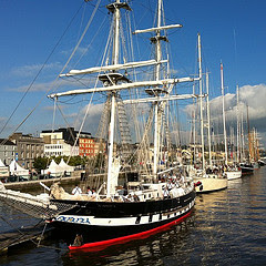
Having successfully mapped the estuary the RV Keary was invited to participate in the Tall Ships Festival. The RV Keary was positioned in Waterford Marina beside The Revenue Commissioners customs cutter, the RCC Faire. The Keary was open to the public from Thursday afternoon June 29th until Saturday evening on July 2nd.

Seabed mapping of the estuary took place in an area west of the city's Rice Bridge to the open sea at the mouth of Waterford Harbour. 
Visitors to the Tall Ships event were invited onboard in groups of approximately 15, and those waiting for the tour were informed of the INFOMAR programme through the display of posters outlining the history of the RV Keary and the INFOMAR programme attached to the vessel’s hull.


The tour commenced on the back deck where a brief introduction to the RV Keary, the
'Real Map of Ireland', the GSI,
Marine Institute (MI), INFOMAR project and the
survey acquisition systems and instrumentation was provided. Visitors were also shown the mapping tools used onboard such as the
side scan sonar, the magnetometer and the
grab sample equipment on the back deck and invited to ask questions on any aspect of the INFOMAR programme.


Following this, the groups were presented with an overview of the data acquired during the Waterford Harbour survey on the data processing pc. Features of interest in the data were highlighted, in particular a 60m shipwreck discovered opposite the marina in Waterford city. This vessel is believed to be the cargo ship the S.S. Harvard, dating from 1870, now embedded in a scour feature in the river bank just a kilometre from where the R.V. Keary was berthed. Also of great interest was the detailed imagery of whirlpool scours (dark blue - purple), created where the river flow meets the tide.


Next the group was invited to view the 'pod' which is located in the middle of the vessel between the two hulls. The pod is designed to accommodate the geophysical equipment onboard such as the single beam head, multibeam heads, chirp, USBL transceiver and SV sensor in one housing. The pod is mounted on a hydraulic ram that can raise and lower the instrumentation into and out of the water. Once the pod has been lowered into the survey position, lateral rams lock the pod in place to ensure that the system is stable and the instrumentation is in the same position each time the pod is moved.
Finally, a tour of the bridge and its instrumentation was provided. The Navigation and Communication Equipment was explained including the POS MV (GPS technology) which logs all motion information in space and time, allowing the removal of the vessels motion from the sonar and shallow seismic datasets. Also, the forward looking sonar which provides information about the nature and depth of the seabed ahead of the Keary and the auto pilot steering of survey lines. A 3D fly-through of Waterford Harbour on display generated huge interest with visitors receiving a 3D visual of the seabed of Waterford harbour.
To the delight of the visitors onboard, RV Keary and Real Map of Ireland postcards were distributed along with copies of
Inshore Ireland ( with Keary articles), and information on the
copper coast geopark project and Marine Institute, not forgetting our younger visitors, the kiddies who received lollipops! The visitors were then free to explore the front deck of the vessel and take photographs.
Over 1,000 people came onboard to visit the RV Keary on guided tours over the three days and the positive feedback and interest in the INFOMAR programme and the data being acquired was exceptional.
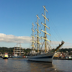
On the final day of a highly successful Tall Ships event, the RV Keary participated in the 'Parade of Sails' on Sunday 3rd July. The parade was led by the naval vessel the L.E. Aoife, followed by the RCC Faire with the RV Keary in third position ahead of the biggest tallship the Russian owned 'Mir' and the remainder of the Tall Ships fleet.
Visit our
Flickr site for more photos.


 Waterford Harbour proved to be both an interesting and challenging environment to survey given the complex currents and steep waves which resulted in challenging sea states in even the calmest of weather. Complicated current patterns and hidden shoals required great skill on the part of the skippers to safely navigate the estuary from Rice Bridge to the harbour mouth, at times needing to manoeuvre the vessels through swirling whirlpools and shifting eddies. Some of the survey lines were run with the vessels “crabbing” sideways against the powerful river and tidal currents that attempted to push them off course. In addition constant changes in salinity and temperature brought about by the interaction of fresh and salt water required that regular sound velocity profiles (SVPs) were carried out. The SVPs were necessary because the sonar systems used to map the seabed measure the travel time of sound waves through the water. As water temperature and salinity differ from within and between survey areas, so too does the speed of sound. Therefore these effects must be corrected for in order to accurately map the seabed. The SVP data were acquired by lowering a probe into the water column, measuring the temperature and salinity of the water and therefore providing the survey team with a record of the sound velocity profile in a given location at a given time (the water column structure can also change over time). By conducting regular sound velocity casts in Waterford Harbour, the team ensured that the final dataset would require minimal processing to correct for errors created by the complicated water structure. The advantage of acquiring this data is that the information gathered during the survey constitute a unique dataset which can have additional use in the study of the local oceanography of the area.
 Below is an image of a possible pipeline running across the main channel in the harbour mouth. The purple boundary on the chart background is a “no-anchorage” zone that has been marked out to enclose the pipeline’s possible location. Following the Keary’s survey, a feature that may be the pipe is visible in the imagery below (marked with a red arrow).
 Other interesting seabed features include possible sand waves generated by the currents, scours that may have been carved out by circulating eddies and prominent outcrops of bedrock. These rock outcrops are interesting as they may be sheets of igneous rock that were intruded into the surrounding sedimentary rock many millions of years ago – otherwise known as igneous “dykes". They have been found elsewhere in this region by geologists mapping onshore.


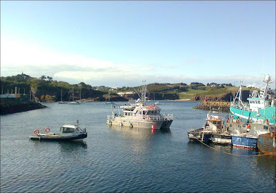
 Below is a series of images of the two vessels at work in Waterford Harbour. The first image shows the RV Keary and RV Geo arriving at Dunmore East.