Showing posts with label INFOMAR. Show all posts

Thursday, 30 May 2013

View new data on Infomar Image Webmapping Site

New data is now available on the Infomar Image Webmapping site and in the INFOMAR webmapping services from the following surveys:

Geo11_01 - Dun Laoghaire, Co. Dublin

KRY11_01 -  Waterford Harbour
Geo11_02 - Waterford Harbour
KRY12_02 – Bunmahon, Co. Waterford
CV11_MeshAtlantic - Kenmare Bay,  Kerry/Cork
CV12_SEAI_Clare - West of Clare
KRY11_03 -  Killard Point, Co. Clare
KRY11_03 – South of Achill Island, Co. Mayo
Geo11_04 - South of Achill Island, Co. Mayo

These are primarily near shore surveys and the location of these new surveys is shown in yellow in the map.
These surveys were carried out by the R.V. Keary, the R.V. Geo and the R.V. Celtic Voyager.  Data produced from these surveys include bathymetry grids, shaded relief and a backscatter images, tracklines and survey polygons.

This image shows bathymetry data from survey around Inishbofin, Inishshark and south of Achill Island.
This is a shaded relief image of bathymetry data collected in Kenmare Bay.
The survey of Kenmare Bay was carried out by the Mesh Atlantic project with support from the INFOMAR project in terms of personnel and equipment. The Mesh Atlantic partnership is compromised of IFREMER, IMA, DIREN Bretagne (France), Marine Institute (Ireland), AZTI, IEO (Spain), ICNB, INRB, Universities of Aveiro, Azores, Algarve (Portugal).

In addition there is also new data on the website for sediment samples.  This includes historical samples in Zone 3 and particle size analysis results for sediment samples taken in 2011 and 2012.

Please note:
  • All of the image layers on this website are also available as WMS services which can be used in ESRI ArcGIS Desktop, ArcGIS Explorer online and other freely available mapping packages, see the Google kml and WMS Links page for details.
  • It is possible to download data used in the site. Use the   button in the tool bar at the top right of the page to click and drag a box around an area of interest, the tool will open our IWDDS download site and you then select the type of data you are interested in downloading.
Please note also to improve performance some of these layers are cached locally onto your computer as you browse the website.  In order to see new data it is necessary to clear the local cache and reload the page.  To do this in:
  • Internet Explorer: click Tools > Delete Browsing History >Check Temporary Internet Files and click Delete.
  • Mozilla Firefox: click Tools > Clear Recent History > Check Cache and click Clear Now
  • Google Chrome: in the Chrome menu select Tools > Clear browsing data > Check Cache and click Clear Browsing data 


Tuesday, 19 June 2012

INIS-Hydro - 2012 Progress

The 2012 survey season began with the RV Keary and RV Geo vessels making a return to Dundalk Bay, to continue mapping as part of the INISHydro Project. Both vessels have been re-mobilised and kitted out with survey instrumentation after wintering in Dublin.

The Geo, a 7.5m RIB operated by the Geological Survey of Ireland, underwent some significant re-fitting - this took the form of an extension to the aft part of the cabin, allowing for a larger work area for the surveyor's station and an equipment rack for the dry end of the survey instrumentation. A generator was also fitted in the Geo's engine bay, which removed the previous reliance on batteries to power the survey gear. These additions have greatly increased the RV Geo's capabilities as a survey craft.


RV Keary arriving into Port Oriel at sunset. Both vessels operated from this harbour, which is situated south of Dundalk Bay

INIS-hydro is a 3 year INTERREG IVA Programme with the Maritime and Coastguard Agency (MCA) in the UK as lead partners. The project brings together 7 partners to conduct hydrographic surveys in Ireland, Northern Ireland and Scotland. The partners are the MCA, Geological Survey of Ireland (GSI), Marine Institute (MI), the Agri-Food and Biosciences Institute (AFBI), the Scotish Association of Marine Science (SAMS), the Northern Lighthouse Board (NLB) and the United Kingdom Hydrographic Office (UKHO).


Areas of seabed to be mapped during the INISHydro project

The surveys will be undertaken in Dundalk Bay, Carlingford Lough, Dundrum Bay, the Firth of Lorn and South West of Islay by several different vessels drawing on expertise from the various partners. The bathymetric data will deliver 3D baseline maps using multibeam echosounder technology which will be freely distributed. The project also plans to harmonise hydrographic survey specifications and synchronisation for future surveys.


INISHydro partner organisations

These surveys comply with the partners obligations under the Safety of Life at Sea conventions and will be augmented with auxiliary scientific data collected in conjunction with the bathymetric data. Details of the project can be found on the website at http://www.inis-hydro.eu/

The project is essential as the current nautical charts for these areas were produced largely in the 19th century and whilst they were an enormous achievement for the surveyors of their day, these charts are not as reliable as their terrestrial counterparts and warrant updating. The territories to be mapped in the INISHydro project encompass important navigation channels, areas of environmental interest and potential sites for marine renewable energy. INISHydro also involves a very significant level of cooperation, bringing together so many partner organisations.


RV Keary and RV Geo in Port Oriel. Note the cabin extension on the Geo, which was added prior to this survey season

INISHydro mapping in 2012 commenced in April, with the arrival of RV Keary and RV Geo in Port Oriel. The vessels worked in partnership, with the Keary focusing on the approaches to Dundalk Harbour and the Geo carrying out survey operations around Dunany Point and the southern, shallow portion of Dundalk Bay.


Strong winds resulted in a rough sea state at times

Due to the exposed nature of Dundalk Bay, operations were sometimes hampered by regular strong, easterly winds. However, in spite of this the vessels significantly extended the bathymetric coverage that was gained last year (bathymetry is the water depth). The Keary mapped out a large wedge-shaped area of seabed that includes an interesting channel-like feature - this feature was also noted in last year's INISHydro blog entry.


RV Keary 2012 bathymetric coverage (does not include RV Geo coverage)

The Geo extended last year's shallow water coverage into an area of shoals around the headland of Dunany Point at the southern extent of Dundalk Bay, along with merging with RV Keary coverage to the east.


RV Geo coverage to date, merging with Keary coverage in the east. Note that the colour scale is different from the previous image - similar colours between the images do not represent the same depth


Mini ROV (Remotely-Operated Vehicle), a valuable tool for inspecting the Keary's propellors


Tuesday, 19 July 2011

The R.V Keary @ Waterford Tallships Festival 2011


The RV Keary, a 15m aluminium catamaran is a state-run marine research survey vessel built for and operated by the Geological Survey of Ireland (GSI). Its primary function is to provide an inshore survey capability for the national INFOMAR programme (INtegrated Mapping FOr the Sustainable Development of Ireland’s MArine Resource).

The RV Keary’s first INFOMAR survey leg of 2011 took place in Waterford Harbour, starting in mid-April and finishing in mid-June.

Click here
for more information.

The campaign focused on mapping the navigational channel in advance of the Tall Ships Festival which took place at the end of June, with mapping of the shallower areas along the river banks and shore being carried out by the GSI's 7.5m RIB, RV Geo. This was the first time that both vessels have worked in tandem.

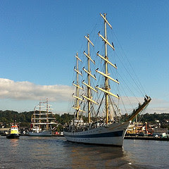
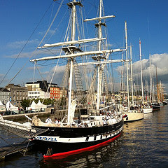
Having successfully mapped the estuary the RV Keary was invited to participate in the Tall Ships Festival. The RV Keary was positioned in Waterford Marina beside The Revenue Commissioners customs cutter, the RCC Faire. The Keary was open to the public from Thursday afternoon June 29th until Saturday evening on July 2nd.


Seabed mapping of the estuary took place in an area west of the city's Rice Bridge to the open sea at the mouth of Waterford Harbour. Photo of RV Keary at Waterford Tallships
Visitors to the Tall Ships event were invited onboard in groups of approximately 15, and those waiting for the tour were informed of the INFOMAR programme through the display of posters outlining the history of the RV Keary and the INFOMAR programme attached to the vessel’s hull.


The tour commenced on the back deck where a brief introduction to the RV Keary, the 'Real Map of Ireland', the GSI, Marine Institute (MI), INFOMAR project and the survey acquisition systems and instrumentation was provided. Visitors were also shown the mapping tools used onboard such as the side scan sonar, the magnetometer and the grab sample equipment on the back deck and invited to ask questions on any aspect of the INFOMAR programme.

Following this, the groups were presented with an overview of the data acquired during the Waterford Harbour survey on the data processing pc. Features of interest in the data were highlighted, in particular a 60m shipwreck discovered opposite the marina in Waterford city. This vessel is believed to be the cargo ship the S.S. Harvard, dating from 1870, now embedded in a scour feature in the river bank just a kilometre from where the R.V. Keary was berthed. Also of great interest was the detailed imagery of whirlpool scours (dark blue - purple), created where the river flow meets the tide.

3D image of shipwreck SS Harvard
imagery of whirpool scours (dark blue - purple), created when the river flow meets the tide in waterford estuary
Next the group was invited to view the 'pod' which is located in the middle of the vessel between the two hulls. The pod is designed to accommodate the geophysical equipment onboard such as the single beam head, multibeam heads, chirp, USBL transceiver and SV sensor in one housing. The pod is mounted on a hydraulic ram that can raise and lower the instrumentation into and out of the water. Once the pod has been lowered into the survey position, lateral rams lock the pod in place to ensure that the system is stable and the instrumentation is in the same position each time the pod is moved.

Finally, a tour of the bridge and its instrumentation was provided. The Navigation and Communication Equipment was explained including the POS MV (GPS technology) which logs all motion information in space and time, allowing the removal of the vessels motion from the sonar and shallow seismic datasets. Also, the forward looking sonar which provides information about the nature and depth of the seabed ahead of the Keary and the auto pilot steering of survey lines. A 3D fly-through of Waterford Harbour on display generated huge interest with visitors receiving a 3D visual of the seabed of Waterford harbour.

To the delight of the visitors onboard, RV Keary and Real Map of Ireland postcards were distributed along with copies of Inshore Ireland ( with Keary articles), and information on the copper coast geopark project and Marine Institute, not forgetting our younger visitors, the kiddies who received lollipops! The visitors were then free to explore the front deck of the vessel and take photographs.

Over 1,000 people came onboard to visit the RV Keary on guided tours over the three days and the positive feedback and interest in the INFOMAR programme and the data being acquired was exceptional.

On the final day of a highly successful Tall Ships event, the RV Keary participated in the 'Parade of Sails' on Sunday 3rd July. The parade was led by the naval vessel the L.E. Aoife, followed by the RCC Faire with the RV Keary in third position ahead of the biggest tallship the Russian owned 'Mir' and the remainder of the Tall Ships fleet.

Visit our Flickr site for more photos.

Le Aoife leads the parade of sails
Russian Tallship Mir following the RV Keary
Le Aoife and RCC Faire lead the Parade of Sails
Tallships in Waterford Marina
Colombian Tallship Gloria
Polish Tallship Polgoria

Tuesday, 9 November 2010

Media Coverage of INSS/INFOMAR from Geoscience 2010 and Atlas of the Deep-Water Seabed: Ireland book launch

Following on from the success of the Geoscience 2010 conference and the launch of the new "Atlas of the Deep-Water Seabed: Ireland" authored by Boris Dorschel and Andy Wheeler of University College Cork (UCC) and Xavi Monteys and Koen Verbruggen of the Geological Survey of Ireland (GSI), there has been lots of coverage of Irish National Seabed Survey (INSS) and INFOMAR datasets in the national media. Here is a sample of recent reports;

> RTE television Six One News with Bryan Dobson & Sharon Ní Bheoláin

04/11/2010: Joe Mag Raollaigh reports from Dublin Castle about the 3D atlas of the mountains and valleys under the sea, west of Ireland. The atlas, which was compiled in UCC, is based on survey work conducted by the Marine Institute and Geological Survey of Ireland. Interview with Keonraad Verbruggen (Geological Survey of Ireland; Joint Manager of the INFOMAR project). Watch by clicking on the image.


> RTE Radio 1 Seascapes


05/11/2010: The " Atlas of the Deep Water Seabed: Ireland" compiled by University College, Cork from data gathered as part of the Irish National Seabed Survey (INSS) and INFOMAR inshore seabed survey undertaken by the Geological Survey of Ireland (GSI), the Marine Institute (MI) and partners, was unveiled this week by Minister of State at the Department of Communications, Energy and Natural Resources, Mr. Conor Lenihan, T.D. at the Geoscience 2010 conference in Dublin Castle.

Click image to access podcasts and select podcast for 5th November 2010. The atlas coverage starts at 7 minutes 34 seconds into the podcast.


> RTE Radio Na Gealtachta Ar Strae sa tSaotharlann

06/11/2010: A new science programme as gaeilge on RTE Radio Na Gealtachta reporting on science news of the week.


Click image to access podcasts and select podcast for "Ar Strae sa tSaotharlann: Dé Sathairn 06 Samhain". The Atlas coverage starts 25 minutes and 8 seconds into the podcast.


> The Irish Times

04/11/2010: A report by Lorna Siggins, Marine Correspondent for the Irish Times about the launch of the atlas and an overview of the INSS and INFOMAR projects.


Click image to access full article.


> The Irish Examiner

04/11/2010: A report by Noel Baker for the Irish Examiner about the launch of the atlas at Geoscience 2010.


Click image to access full article.


> Afloat Magazine Website

03/11/2010: A report by Ireland's Sailing and Boating magazine about the launch of the atlas at Geoscience 2010.


Click image to access full article.


> University College Cork Media and Communications News Website

05/11/2010: Article about the launch of the atlas at Geoscience 2010.

Click image to access full article.


> Geological Survey of Ireland Website

03/11/2010: Article about the launch of the atlas at Geoscience 2010.


Click image to access full article.


> Marine Institute Website

03/11/2010: Article about the launch of the atlas at Geoscience 2010.


Click image to access full article.

More information about the Atlas can be found here

Wednesday, 20 October 2010

INFOMAR at Geoscience Conference 2010

A two-day conference on the Geoscience Sector will take place in Dublin Castle on the 3rd and 4th November 2010. The morning sessions of the first day of the conference will focus on INFOMAR specific topics such as survey progress in 2010, the first full year of survey operations with the RV Keary and the success of the 2010 LiDAR campaign with Pelydryn.

The late morning and afternoon will look at where Irish National Seabed Survey and INFOMAR data has been and is being used in marine science research including deepwater reefs, carbonate mounds, seabed classification, seabed morphology and many other areas of research.

There is no charge for attending the event but those interested should confirm their interest by e-mailing michael.o'mahony@gsi.ie

Official agenda for both days can be found here.

Friday, 15 October 2010

CV10_03 Cork and Waterford

The final INFOMAR survey of 2010 onboard the Celtic Voyager took place from the 26th September to the 5th October off the coast of Cork and Waterford from Ballycotton to Mine Head, continuing work from the second part of the CV10_02 leg earlier in the year.

Overview of multibeam sonar coverage achieved during the Celtic Voyager survey in the Southern Priority Area off Cork and Waterford.

This survey successfully joined datasets from 2008 off Cork and 2007 off Waterford and Wexford to form a continuous band of survey data from the Old Head of Kinsale, Co. Cork to Carnsore Point, Co. Wexford.


Coverage extents from INFOMAR surveys with the Celtic Voyager from 2007, 2008, 2009 and 2010 linking datasets from the Old Head of Kinsale east to Carnsore Point, covering a significant portion of the Southern Priority Area.

Multibeam sonar data of the wreck of the SS Bandon. This Irish cargo steamer of 80 metres in length was torpedoed by German U-Boat, UC-44 S of Mine Head on 13th April 1917. 28 crew were killed in the attack.

Further information on the wrecks surveyed by INFOMAR is available here.

Photograph of Ballycotton lighthouse from the Celtic Voyager.

All INFOMAR data is available for free download here.

Wednesday, 13 October 2010

CV10_02 Wexford Waterford and Cork

In July, the RV Celtic Voyager continued to survey the seabed off the coast of Wexford, Waterford and Cork. This data will be included in individual INFOMAR priority bays such as Waterford Harbour and also in the Southern Priority Area which extends from Carnsore Point, Co. Wexford westward along the south coast of Ireland. This leg was divided into two parts with the first period concentrated in an area between Hook Head and the Saltee Islands, continuing on from survey coverage achieved in 2009 on CV09_03. The Celtic Voyager has now surveyed a large portion of this area and the remaining shallow, nearshore area will be finished by the RV Keary in the future.

Overview of survey work completed by the Celtic Voyager off the Wexford coast in July with existing INFOMAR survey work shown in the hatched area.


Area of detail from the multibeam sonar data for an area of seabed SW of the Great Saltee. The is an interesting feature west of the Conningmore Rocks which is possibly an area of sediment accumulation in the lee of the rocks due tidal currents. West of this feature is a shallow area of rock outcrop known as the Red Bank.

Area of detail from the multibeam sonar data for an area of rock outcrop on the seabed E of Hook Head showing complex structural geology with folding and faulting evident on the dataset. Future survey work and research may be useful in interpreting and linking these datasets to the diverse onland geology seen on Hook Head.

With the area of seabed off Wexford surveyed, operations moved down the coast to begin surveying an area that linked data acquired by the Celtic Voyager in 2008 off Cork and data from 2007 off Waterford.

Overview of survey work completed by the Celtic Voyager off the Cork and Waterford coast in July with existing INFOMAR survey work shown in the hatched area.


Plan view of multibeam sonar dataset showing the wreck of the Etal Manor on the seabed south of Hook Head. The c. 80 m Etal Manor was a British cargo steamer that was torpedoed in 1917 by German U-Boat UC-48 resulting in the deaths of 6 onboard.

Further information on the wrecks surveyed by INFOMAR is available here.

All INFOMAR data is available for free download here.

KRY10_03 Clifden and Mannin Bay

On completion of the survey portion of work in Kinsale, the RV Keary made the transit to Clifden Bay to begin mapping in Clifden Bay, Mannin Bay and the seabed outside the bays, north of Slyne Head to Cruagh Island. The inner most and shallowest areas of the bays had been surveyed using LiDAR earlier in the year. Click here for more information on that LiDAR survey.

Overview image of multibeam sonar data of all coverage achieved in Clifden and Mannin Bays. LiDAR coverage is represented by the hatched area.

Initially the survey was concentrated in the deeper water areas, seaward of the bays. It was in this area, NE of the Barret Shoals that a steep outcrop of rock rising to a chart depth of 12.2 metres in surrounding water depths of 30 to 40 metres was mapped for the first time. This significant shoal was surveyed in detail and a H102 note was prepared for the United Kingdom Hydrographic Office (UKHO) so that this shoal location can be quickly updated in the charts as a possible danger to navigation.

Datasets showing the previously uncharted shoal mapped during INFOMAR survey KRY10_03, NE of the Barret Shoals.

Multibeam sonar data showing three charted shoals mapped west of Clifden Bay during INFOMAR survey KRY10_03. The data shows that water depths are shallower (shown as red and orange colours) over these rock outcrops than the surrounding seabed (shown as green and blue colours) and can present a danger to navigation.

Entrance to Clifden Bay with the beacon on Errislanan marking the southern entrance of the bay. In the background are the Twelve Pins mountains of Connemara. The ruins of Clifden castle can also be seen in the centre of the photograph. The RV Keary anchored in Clifden Bay during the survey of Clifden and Mannin Bay.

All INFOMAR data is available for free download here.