Friday, 21 February 2014

Dingle Bay 2013

From 18th June to 21st July 2013, INFOMAR vessels operated by the Geological Survey of Ireland (GSI) carried out survey operations in Dingle Bay. This seabed mapping extended multi-beam coverage that had previously been acquired by the Marine Institute (MI) in 2009. During that survey leg, the MI research vessel Celtic Voyager mapped the bulk of the deeper waters of the bay.

The GSI vessels R.V. Keary, M.V. Cosantóir Bradán and R.V. Geo finalised the seabed map by focusing their efforts on the shallower waters along the coast, along with surveying areas of seabed around the islands of Great Blasket, Inishnabro, Inishvickillane, Tearaght and Inishtooskert. The figure below shows the extent of each vessel's survey leg, including the 2009 leg operated by the R.V. Celtic Voyager.

Click on the image to see a larger view. The legend displays colours for the following survey legs: KRY13_04 (R.V. Keary), CB13_03 (Cosantóir Bradán), GEO13_03 (R.V. Geo), CV09_02 (R.V. Celtic Voyager).

Dingle Bay Survey Legs


The M.V. Cosantóir Bradán and the R.V. Geo began surveying in late June, with the R.V. Keary joining the operation in early July. The Cosantóir initially focused her efforts on mapping the waters off the coast of Inch and Rossbeigh beaches in the inner bay, while the Geo mapped the shallow waters of Ventry and Dingle harbours and a narrow strip running along the northern coastline of the bay. Once her operations in the inner bay were complete, the Cosantóir mapped a large area of seabed around the Great Blasket and Inishtooskert islands, along with an area to the north of Valentia Island. Once the Keary was on site, she carried out survey operations off the coast of Coumenole Beach and an area of seabed around the islands of Inishnabro and Inishvickillane. Both vessels mapped either side of Tearaght Island. The R.V. Geo also carried out mapping north of Valentia island.

For further information on the survey vessels operated by the GSI and the MI, see http://www.infomar.ie/surveying/Vessels.php. Below are images of the three GSI vessels that took part in this survey:

R.V. Keary

M.V. Cosantóir Bradán

R.V. Geo

Below is a series of images detailing the bathymetric data (water depths) acquired during the 2013 Dingle Bay Survey. Note that this data is still in the process of being finalised and checked for errors and therefore contains some inaccurate depth information. The units of the colour scales are "metres below LAT" (Lowest Astronomical Tide) and are included to give an approximate impression of water depth.

Several areas mapped were found not to agree with existing nautical charts - notifications of these hazards were sent to the United Kingdom Hydrographic Office for the purposes of chart corrections.


Overally Bathymetry for 2013 Survey


Note the survey lines crossing the middle of the bay - these were mapped while the vessels were in transit to and from their survey areas around the edges of the bay. This data can be compared with Celtic Voyager data in the same areas for the purposes of quality control.

Dingle Harbour


Ventry Harbour

Shallow bank off the coast of Inch (note: this image uses a different colour scale range from the other images)


Inishtooskert and Great Blasket Islands


Inishnabro and InishVickillane


Craggy coastline of Inishnabro island

 Jagged rock in Ventry harbour


R.V. Geo surveying near the cliffs of the Iveragh Peninsula


Tuesday, 11 February 2014

INIS-Hydro Completion

Between May and June 2013, INFOMAR survey vessels carried out seabed mapping operations in Dundalk Bay, finalising their contribution to the INIS-Hydro Project.

This was the completion of mapping that began in 2011 - see the following blogs for details: http://infomarupdates.blogspot.ie/2011/11/inishydro-project.html and http://infomarupdates.blogspot.ie/2012/06/inishydro-2012-progress.html

INIS-Hydro was a 3 year INTERREG IVA Programme with the Maritime and Coastguard Agency (MCA) in the UK as lead partners. The project brought together 7 partners to conduct hydrographic surveys in Ireland, Northern Ireland and Scotland. The partners are the MCA, Geological Survey of Ireland (GSI), Marine Institute (MI), the Agri-Food and Biosciences Institute (AFBI), the Scotish Association of Marine Science (SAMS), the Northern Lighthouse Board (NLB) and the United Kingdom Hydrographic Office (UKHO).

The surveys were undertaken in Dundalk Bay, Carlingford Lough, Dundrum Bay, the Firth of Lorn and South West of Islay by several different vessels drawing on expertise from the various partners. The bathymetric data delivered 3D baseline maps using multibeam echosounder technology which will be freely distributed. The project aims to harmonise hydrographic survey specifications and synchronisation for future surveys.

Dundalk Bay was surveyed by the Marine Institute (MI) and the Geological Survey of Ireland (GSI), who took responsibility for blocks 1 and 2, respectively, as shown in the image below:


Block 1 was surveyed by the R.V. Celtic Voyager, while the GSI vessels R.V. Keary, R.V. Geo and M.V. Cosantóir Bradán surveyed the shallower waters of Block 2 (though elements of block 1 were also surveyed by the M.V. Cosantóir Bradán).

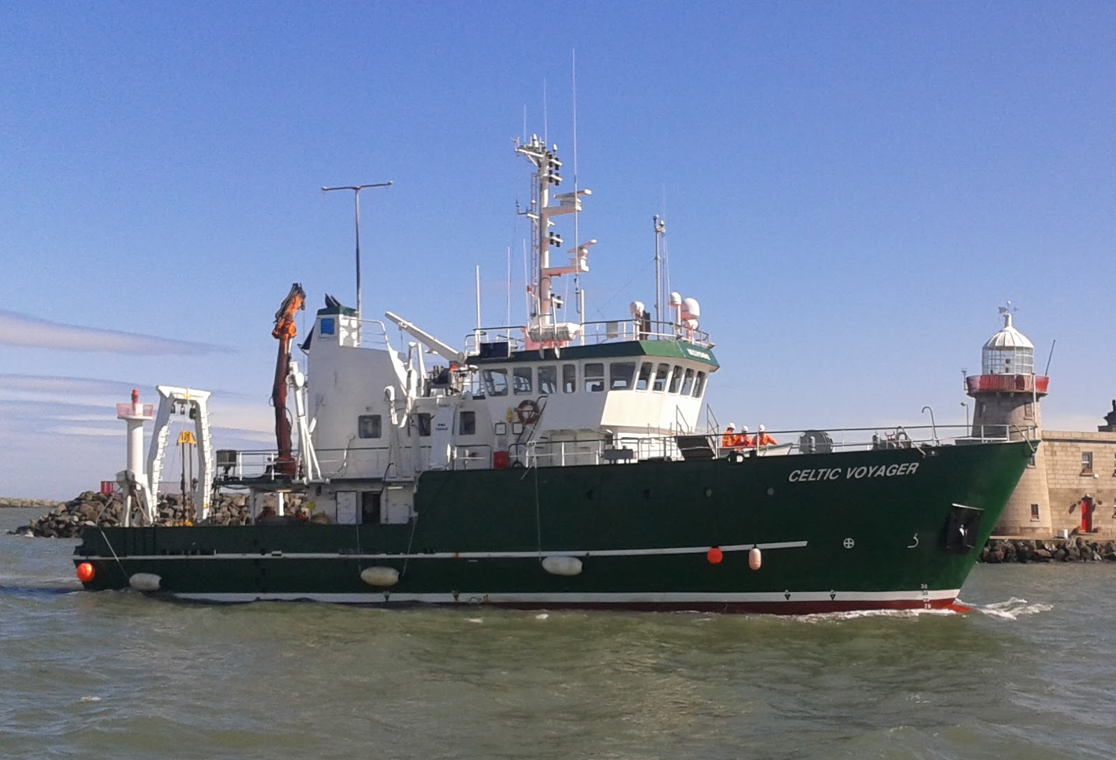
R.V. Celtic Voyager

R.V. Keary


R.V. Geo


M.V. Cosantóir Bradán

Overall, seven seperate survey legs were required to complete the mapping of this large area. The following image shows the extent of each of these survey legs. Each leg is coded according to the vessel that undertook it (Celtic Voyager = CV, Keary = KRY, Geo = GEO and Cosantóir Bradán = CB), followed by the year and that vessel's particular leg number of that year (e.g. KRY11_06 is the Keary's sixth survey leg of 2011 - the previous 5 survey legs would have taken place in other locations around the Irish coast).


The following image shows the bathymetric data (water depths) acquired over all seven legs:


The mapping of Dundalk Bay was a challenging endeavour. Exposed to many wind directions, the vessels engaged in shallow water mapping were often hampered by the weather. Easterly winds were particularly disruptive to survey operations, as the quality of acquired data diminishes rapidly with increasing wind (and therefore, choppier seas). In addition to this, the shallow nature of the inner bay extended the duration of the overall project. The reason for this is that the width of the track mapped by each pass of a survey vessel actually narrows as the water depth decreases, increasing the time it takes to map a given area as the vessel moves into shallower waters.The R.V. Geo in particular had to contend with this law of diminishing returns.

Three interesting shipwrecks were imaged as part of the mapping process. They are visible in the following images:

Sunken meteorological station - 3D view

 The Topaz - 3D view (wreck information sheet at http://www.infomar.ie/data/Shipwrecks/Box45/pdfs/SSTopaz_Final.pdf)

The Crusader

Along with the shipwrecks, a host of other interesting seabed features were mapped, including this large channel feature in the centre of the bay:


A backscatter image was also produced during processing of the bathymetric data. This image is a measure of the strength of the reflection of the vessels' sonar pulses off the seafloor - thus giving an impression of relative hardness of different seabed types. In the backscatter image below, darker patches are indicative of harder seabed types:


In addition to the seabed mapping operations, the R.V. Keary and the R.V. Celtic Voyager also carried out seabed sampling. This process involves lowering a device to the seafloor, called a grab sampler, which on impact closes a pair of jaws and retrieves a sample of whatever sediment type is there. See the following video clip for a demonstration of this: http://www.youtube.com/watch?v=B06Fw0MEfd0. The following map shows the locations at which seabed sampling was carried out:


The following images show examples of sediment types retrieved from the seabed (sand and gravel, respectively):


Wednesday, 28 August 2013

INFOMAR reports on a successful survey season - 2013

V. Quinlan, K. Sheehan, F.Sacchetti

INFOMAR continued its survey activities in the south of the country into August. During this survey period INFOMAR completed the important South Priority Area (SPA) which stretches from near Toe Head in the southwest to Carnsore Point in the northeast.
RV Celtic Voyager operations commenced in Clonakilty Bay off the Cork coast in early July and for a period of four weeks seabed mapping continued into Glandore Bay, Baltimore Bay, Long Island and Roaring water Bay and a number of smaller bays in this region.


Figure1. Extent of Multibeam coverage during July & August 2013

The survey area included the important Special Area of Conservation (SAC) for marine mammals which encompasses Roaring water and Long Island bays. Mapping within the SAC requires a special license agreement, which was granted by National Parks and Wildlife Service (NPWS). The survey was conducted during day light hours exclusively, in compliance with the Code of Practice for the Protection of Marine Mammals during Acoustic Seafloor. Ports of significance in the area include Crookhaven, Schull, Baltimore, Cape Clear and Glandore. Water depths range from 10 to 100 meters.
Strong currents, shoals, and fishing gear made for exciting times mapping the Gascanane sound which separates Cape Clear and Sherkin Islands. This sound is regularly used by the Baltimore to Cape Clear ferry and by numerous fishing boats and pleasure crafts.
The seabed in the sound is extensively scoured by strong tidal currents, forming impressive holes of up to 50 meters depth.


Figure 2. Bathymetry image of Gascanane sound with scour holes evident.

Favorable weather periods were utilised to survey close in to the iconic feature that is the Fastnet rock. Survey data from both the Geological Survey of Ireland vessel; RV Keary and RV Celtic Voyager were required in order to map this area safely and to acquire full coverage.


Figure 3. Fastnet Rock (Photo courtesy of Nicola O'Brien)

Bad weather conditions on 31st July meant an unscheduled portcall in Castletownbere (figure 4), County Cork. Castletownbere is the biggest fishing port in the south of Ireland. Figure 4 shows the inner harbour. The weather downtime allowed the data processors to get through a backlog of processing and for the crew to do some maintenance and painting that they don’t get the opportunity to do while at sea.


Figure 4: Castletownbere Harbour.

Wrecks
A total of nine wrecks were mapped. Figure 4 below is an image of a wreck discovered on this survey. This wreck is previously uncharted and appears to be that of a submarine. This is currently under research, the outcome will no doubt be an interesting story. All the wrecks are initially identified from the main multibeam survey lines and are then mapped in detail using a 'box in' process of three parallel lines and one perpendicular line. Multibeam water column data is also acquired in order to maximize the mapping effort and ensure that small objects such as masts are also mapped. This effort produces the detail required both for identification and charting purposes.


Figure 4 A possible submarine.

The survey demobilised in Galway on 7th August 2013.

Saturday, 1 June 2013

INFOMAR 2013 - CELTIC VOYAGER MAPPING SOUTHERN PRIORITY AREAS AND BAYS


INFOMAR Survey CV13_01

Monday 22nd April saw the commencement of the first RV Celtic Voyager INFOMAR survey leg of 2013, named CV13_01. Operations commenced off the Cork coast between Ballycotton and Youghal, shoreward of coverage attained in previous years.  The area forms part of the South Priority Area (SPA), stretching from Mizen Head in the south-west to Carnsore Point in the north-east.  The Priority Bays of Youghal and Dungarvan were also partially surveyed. Figure 1 shows the extent of multibeam coverage achieved in the area while figures 2, 3 and 4 show detailed seabed morphologies of the bays of Ballycotton, Dungarvan and Youghal respectively.   

Figure 1: Multibeam inshore survey coverage between Ballycotton and Dungarvan.

 
Figure 2: Seabed geomorphology offshore Ballycotton.
 
 Figure 3: Seabed geomorphology offshore Dungarvan.

 
Figure 4: Seabed geomorphology offshore Youghal.

Survey operations alternated between the inshore area above and an offshore block south of Waterford, shown in figure 5. The offshore survey block covers an area of approximately 320 km2. Water depths range from 50 m to 80 m approximately with depths increasing from north to south. The seabed is mostly covered by sediment but outcropping rocks are also found in the north.

Figure 5: Offshore survey block south of Waterford.

An area east of Wexford and west of the Blackwater Bank was also mapped during a period of strong westerly winds. The multibeam shaded relief image in figure 6 shows that the seabed is largely composed of sediment waves. Water depths vary from 10 to 25 m approximately.

Figure 6: Multibeam image near Blackwater Bank Wexford.

Survey operations moved west for the final week of survey. The area included the waters around Old Head of Kinsale and Courtmacsherry Bay (figure 7). Its offshore extent was along the SPA boundary, more than 12 km offshore of the Old Head of Kinsale. Water depths ranged from 12 m to 100 m approximately. The extent of the mapped area was approximately 400 km2. Several magnetic anomalies were observed, attributed to the geology. Survey operations finished on 31st May. The Celtic Voyager remained operational for over 70% of the total time.


Figure 7: Multibeam image of Courtmacsherry Bay and Offshore Kinsale.

Wrecks

A total of 21 wrecks were mapped during this leg. Figure 8 shows an image of a wreck off the Waterford coast. The wrecks were initially identified from the main survey lines and then mapped in detail using a standard box in process of three parallel lines and one perpendicular line with multibeam water column data and magnetometer data acquired on each line.


Figure 8: Multibeam image of mapped wreck.

Groundtruthing stations

In total 128 groundtruthing stations were visited. A total of 111 samples were acquired from these stations, with no returns at 17. A Shipek grab was used throughout. Each sample was photographed and described. Samples varied from mud through to gravel. Figure 9 shows a photograph of the sample obtained at station 4.


Figure 9: Shipek Grab sample photograph.

Figure 10 is a distribution plot of the visited groundtruthing stations. Each red X marks a station.


Figure 10: Groundtruthing spatial distribution plot.

Sub Bottom Profiler Data

Sub bottom profiler data was acquired on each survey line. Figure 11 below shows an example of sub bottom profiler data with a palaeochannel in the view. Each horizontal red line represents 8 metres depth. The vertical blue lines are approximately 120 metres apart. The horizontal line near the top of the image represents the seabed return.


Figure 11: Sub-Bottom-Profiler data example.


Thursday, 30 May 2013

View new data on Infomar Image Webmapping Site

New data is now available on the Infomar Image Webmapping site and in the INFOMAR webmapping services from the following surveys:

Geo11_01 - Dun Laoghaire, Co. Dublin

KRY11_01 -  Waterford Harbour
Geo11_02 - Waterford Harbour
KRY12_02 – Bunmahon, Co. Waterford
CV11_MeshAtlantic - Kenmare Bay,  Kerry/Cork
CV12_SEAI_Clare - West of Clare
KRY11_03 -  Killard Point, Co. Clare
KRY11_03 – South of Achill Island, Co. Mayo
Geo11_04 - South of Achill Island, Co. Mayo

These are primarily near shore surveys and the location of these new surveys is shown in yellow in the map.
These surveys were carried out by the R.V. Keary, the R.V. Geo and the R.V. Celtic Voyager.  Data produced from these surveys include bathymetry grids, shaded relief and a backscatter images, tracklines and survey polygons.

This image shows bathymetry data from survey around Inishbofin, Inishshark and south of Achill Island.
This is a shaded relief image of bathymetry data collected in Kenmare Bay.
The survey of Kenmare Bay was carried out by the Mesh Atlantic project with support from the INFOMAR project in terms of personnel and equipment. The Mesh Atlantic partnership is compromised of IFREMER, IMA, DIREN Bretagne (France), Marine Institute (Ireland), AZTI, IEO (Spain), ICNB, INRB, Universities of Aveiro, Azores, Algarve (Portugal).

In addition there is also new data on the website for sediment samples.  This includes historical samples in Zone 3 and particle size analysis results for sediment samples taken in 2011 and 2012.

Please note:
  • All of the image layers on this website are also available as WMS services which can be used in ESRI ArcGIS Desktop, ArcGIS Explorer online and other freely available mapping packages, see the Google kml and WMS Links page for details.
  • It is possible to download data used in the site. Use the   button in the tool bar at the top right of the page to click and drag a box around an area of interest, the tool will open our IWDDS download site and you then select the type of data you are interested in downloading.
Please note also to improve performance some of these layers are cached locally onto your computer as you browse the website.  In order to see new data it is necessary to clear the local cache and reload the page.  To do this in:
  • Internet Explorer: click Tools > Delete Browsing History >Check Temporary Internet Files and click Delete.
  • Mozilla Firefox: click Tools > Clear Recent History > Check Cache and click Clear Now
  • Google Chrome: in the Chrome menu select Tools > Clear browsing data > Check Cache and click Clear Browsing data 


Thursday, 23 May 2013

Lambay Island Survey

From late April to May 2013, the M.V. Cosantóir Bradán and R.V. Geo carried out survey operations around Lambay Island and along the coast between Howth and Skerries, Co. Dublin. This seabed mapping was carried out on behalf of the National Parks and Wildlife Service (NPWS - http://www.npws.ie/), who requested the survey so they could delineate habitats in the area. Survey coverage was also extended beyond the NPWS requirements in order to expand INFOMAR national mapping coverage in the area.
 
The M.V. Cosantóir Bradán is the latest addition to the INFOMAR survey fleet and is operated by the Geological Survey of Ireland (GSI). A fisheries patrol vessel in a previous life, she is now outfitted with a multibeam sonar mapping system - http://www.fisheriesireland.ie/Press-releases/minister-commissions-an-cosantoir-bradan-in-her-new-role-as-a-seabed-survey-vessel-at-infomars-2012-annual-conference.html.
The transducers (these are the part of the system that send and receive the sonar pulses) are deployed by means of a bow-mounted hydraulic frame.
 
The R.V. Geo is also operated by the GSI and is a 7.5m RIB (Rigid Inflatable Boat). She is equipped with an interferometric sonar mapping system, which is manually deployed by means of a bow-mounted frame.

Note: data shown in images below is not yet finalised and may contain some errors.

Overall survey coverage by M.V. Cosantóir Bradán and R.V. Geo


Close-up of survey coverage around Lambay Island


M.V. Cosantóir Bradán (Crosshaven, 2012)
 
 
R.V. Geo (Killary Harbour, 2012)